For official trail conditions and travel information, visit Visit Madeira, the UNESCO Laurissilva Forest page, and ICNF, Portuguese Nature Conservation Institute.
Local Wisdom, The Levada I Walk in Silence
Most visitors rush to 25 Fontes because it appears on every top-10 list. I understand why, the waterfall is dramatic, the tunnel is an adventure. But here is what I have learned after walking these levadas for years: the top levada experience on Madeira is not the destination, it is the walk itself, and for that, you want a levada without a famous endpoint. Levada do Rei in São Jorge is my choice. You walk through primordial laurel forest where the silence is broken only by water dripping from the canopy and chaffinch calls echoing through the trees. No tour groups, no selfie queues, no one rushing past you. The first time I walked it, I stopped counting after 20 minutes because I had not seen another person. That never happens at 25 Fontes. Go on a weekday morning in May or October, the forest smells of wet earth and wild laurel blossom, and you will understand why Madeirans call the levadas the island's veins.
The first time I followed a levada, I didn't understand why anyone would walk alongside a 500-year-old irrigation channel. Then I reached the balcony at Balcões and understood: the levada IS the path, but also the destination, the sound of running water, the laurel forest canopy overhead, and suddenly a view of Pico do Arieiro and Pico Ruivo stretching across the sky.
After walking 400+ km of these trails, I've come to see levadas as Madeira's hidden infrastructure of wonder. They were built from the 15th century onward to carry water from the rainy northwest to the agricultural south, a hydraulic engineering network spanning 1,300+ miles, now walking routes through the UNESCO-listed Laurissilva forest, the largest surviving laurel forest in the world.
I met a levada keeper named Sr. António on the PR9 trail near Ribeiro Frio. He was in his sixties, knee-deep in a channel, clearing silt with a metal rake while his dog slept on the path. I stopped to ask about the trail ahead, and he spent 20 minutes explaining how the 15th-century system actually works, that water rights are still allocated by the same "rodízio" (rotation) system the original settlers designed, where each farmer gets the flow for a set number of hours per week. He pointed to moss patterns on the channel walls to show where the water level should be. I think about Sr. António every time I walk a levada.
Difficulty spectrum: Easy (Balcões, Alecrim) → Moderate (25 Fontes) → Challenging (PR1) → Extreme. Each has a different vertigo profile, time commitment, and footwear requirement.
The key question: Should you go with a guide or self-guided? For 25 Fontes, I recommend a guide, not because you can't find it, but because the official path includes an 800m pitch-black tunnel that's genuinely disorienting alone. Guides also know the secret Risco waterfall detour most self-guided walkers miss entirely. For Alecrim? Go solo. The trail is well-marked, parking is the same, and you'll want to sit in silence at the waterfall.
Season matters. May through October offers the driest conditions. Between November and March, trails can get muddy and waterfall volumes are higher. I did Levada do Alecrim in November when the forecast said "light rain", I got a 30-minute downpour that turned a gentle trail into a gully, water rising 25cm in the channel in 20 minutes. Check IFCN trail status before heading out.
Below we compare the most popular levada routes by difficulty, scenery, and vertigo exposure. If you're new to levada walking, start with our beginner's guide or jump to the full difficulty comparison.
⚠️ Honesty Box, Which Levada to Skip
- 25 Fontes is not for anyone who hates crowds between 10 AM and 3 PM. At peak times you'll share the waterfall with 200+ people. Go before 9 AM or after 3 PM. Or skip it entirely and do Alecrim instead, same parking, fewer people, still a waterfall.
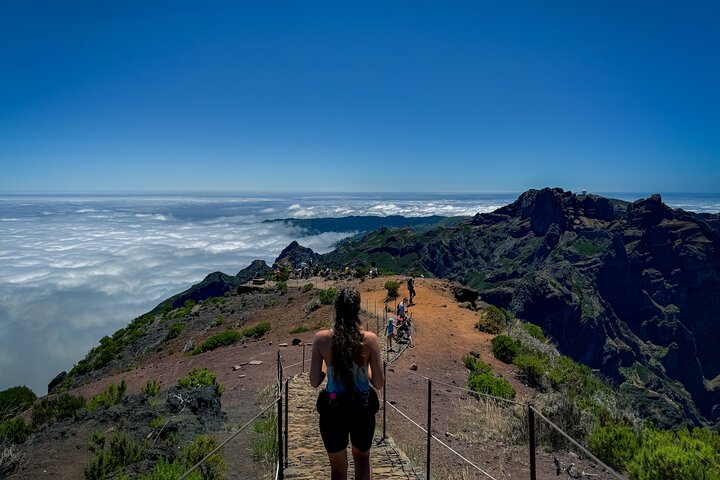
- PR1 is not for knee problems or vertigo. The descent back to Arieiro involves 800m of stone staircases. The exposed ridge sections have sheer drops of 300m+. If you have even mild vertigo, take PR1.2 instead.
- Self-driving PR1 without a transfer? You'll need two cars or a 6-hour round trip back up the staircase section. The sunrise transfer is worth every euro.
⚠️ Hiking Safety Disclaimer
Mountain hiking carries inherent risks. Trail conditions change daily due to weather, maintenance, and seasonal factors. Always assess your fitness level honestly before attempting any trail described on this site.
- Check trail status: Visit ifcosteiros.pt for official trail closures and conditions before setting out.
- Emergency: Dial 112 for mountain rescue and emergencies throughout Portugal.
- Check weather: Consult the IPMA weather forecast for mountain conditions before departing.
Essential carry items for every hike:
- 🔦 Head torch with fresh batteries
- 📱 Fully charged phone with offline maps
- 🧵 Waterproof jacket
- 👕 Extra warm layer
- 💧 1.5L water minimum
- 📢 Whistle
Legal Disclaimer: The information on this website is provided for general informational purposes only. Trail descriptions, difficulty ratings, and conditions are based on personal experience and may not reflect current conditions. Always exercise due diligence, consult official sources, and prioritise your safety. Madeira Hiking Tours accepts no liability for injury, loss, or damage arising from the use of this information.
What to Bring on Levada Walks
- Waterproof jacket, not a poncho. Levada paths are narrow, often less than 1m wide with a drop on one side. A poncho catches on branches, flaps in the wind, and obstructs your view of where you are placing your feet. A fitted rain shell lets you move freely.
- Hiking boots with ankle support, not trail runners. Levada surfaces alternate between packed earth, wet rock, and wooden walkways slick with moss. I have watched people in trainers slide sideways into the levada channel itself. Your feet will get wet regardless, the ankle support is what keeps you upright.
- A small torch even on daytime walks. Every levada tunnel is darker than you expect. Even the short ones, 30 metres of total blackness feels much longer when you cannot see the exit. A dedicated torch leaves your phone battery for photos at the waterfall.
- Cash in coins (€1 and €2). Mountain cafés at Ribeiro Frio, Queimadas, and Rabaçal sell hot coffee and bolo do caco for pocket change, but their card machines fail regularly due to poor signal. A €5 note is useless when the coffee costs €0.70 and the owner has no change.
Counterintuitive tip: Walk the levada in the direction the water flows, not against it. The levadas were engineered with a gentle gradient, walking downhill with the current is noticeably easier on your knees over 10+ km. Most guided tours do this, but self-guided walkers often park at the wrong end and spend the whole day fighting the gradient.
Explore More
Related comparisons and guides:
- PR1 vs PR1.2: Which Route to Pico Ruivo Is Right for You?
- PR1 vs PR1.2 Madeira: Which Pico Ruivo Hike Should You Choose?
- East vs West Madeira 4×4 Tour: Which Side Should You Explore?
- Private vs Group 4×4 Jeep Tours: Is the Upgrade Worth It?
- Ponta de São Lourenço (PR8): The Coastal Trail With No Shade

Last updated: May 2026
We earn a commission when you book through our links on Viator, at no extra cost to you. This is how we keep the site free.