East vs West Madeira 4×4 Tour: Which Side Should You Explore?
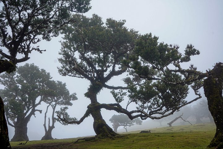
The first time I drove the west circuit, I spent 20 minutes lost in Fanal Forest in fog so thick I couldn't see my boots. I'd read the blogs, "beautiful," "like a fairy tale", and wanted the famous photo of the gnarled laurel trees in mist. What I got was fog so thick I followed what I thought was the trail for 20 minutes before realizing I was walking in a circle, my own footprints confirmed it. No phone signal, no trail markers visible. I stood still, listened for the road, and followed the sound of occasional car engines. It took 45 minutes to get back. A 4×4 tour would have solved that entirely, the driver knows the forest, the fog patterns, and exactly where the photo spots are.
After walking 400+ km of Madeira trails, I've explored both circuits multiple times. The east route gives you mountain peaks and cultural villages. The west gives you coastal drama and ancient forests. Both are excellent. But they show you completely different Madeiras. I recommend booking a East Jeep Safari for the most rewarding experience.
Madeira's mountainous interior is ideally explored by 4×4. The island's jeep safari operators split it into two classic full-day routes: east and west.
Choose East if you want Madeira's most dramatic mountain scenery, Pico do Arieiro, the UNESCO laurel forest, Santana's thatched houses, and Ponta de São Lourenço's lunar situation. Choose West for coastal drama, Porto Moniz natural pools, the ancient Fanal forest, Cabo Girão skywalk, and waterfall-draped cliffs. If you can only do one: East wins for first-time visitors.
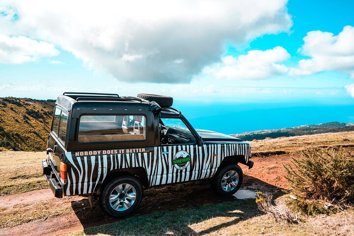
East 4×4 Tour
Mountain peaks, UNESCO laurel forest, traditional thatched houses, and the dramatic eastern peninsula.
For official trail conditions and travel information, visit Visit Madeira, the UNESCO Laurissilva Forest page, and ICNF, Portuguese Nature Conservation Institute.
Local Wisdom, East vs West: What the Guidebooks Miss
Everyone asks me "east or west?" and the answer depends on something nobody mentions: cloud cover. Madeira east side (Pico do Arieiro, Ponta de São Lourenço) is drier and clearer, the prevailing winds hit the north coast and dump moisture there. The west side (Fanal Forest, Porto Moniz) is greener, wilder, and far more likely to be foggy or raining. I have done the west circuit three times. Twice, Fanal Forest was so fogged in we could not see the famous til trees. Once, it was clear and they looked like something from a Miyazaki film. My rule: book the east circuit if the forecast shows clouds above 1,000m. Book the west circuit if it is a clear day. If you can only do one, east is more reliably impressive. West is higher risk, higher reward.
East Circuit in Detail: Pico do Arieiro to Ponta de São Lourenço
What to Bring on Either Circuit
East circuit: Sunglasses and windproof jacket (Ponta de São Lourenço is exposed with zero shade). West circuit: Rain jacket (the north coast gets more precipitation than anywhere else on the island). Swimwear: if your West circuit stops at Porto Moniz natural pools or Seixal black sand beach. Cash for poncha: The top poncha on the island is at a roadside bar in Serra de Água. The driver will know which one. Both: Layers, sunscreen, camera with strap, motion sickness meds if prone.
The east 4x4 circuit covers approximately 100 kilometres and takes 3.5-4 hours for the half-day version. The standard itinerary begins with a climb from Funchal (sea level) to Pico do Arieiro at 1,818 metres, following the ER110 through the central massif. The road passes through the Monte and Poiso areas, where eucalyptus forest gives way to high-altitude tree heath above 1,400 metres. At the summit, the tour typically stops at the same viewpoint as the walking trailhead, offering a view across the central peaks to the north coast on clear days.
From Arieiro, the route descends the north face of the massif through a series of switchbacks into the Santana valley. Santana is known for its triangular thatched-roof houses (the palheiros), three of which are preserved as a museum at the town centre. The descent continues to Faial on the north coast, then follows the coastal road east toward Ponta de São Lourenço - the easternmost point of Madeira. The situation here changes abruptly from the green interior to an arid, desert-like terrain with red volcanic soil, yucca plants, and views of Porto Santo island on clear days. The final stop before returning is at Prainha, a small natural beach with dark volcanic sand.
West Circuit in Detail: Fanal Forest to Porto Moniz
The West Jeep Safari route is the more popular of the two options, and for good reason: it covers Madeira's most famous natural landmarks in a single day without feeling rushed. The tour departs Funchal around 9 AM, climbs through Ribeira Brava's switchbacks to Paul da Serra at 1,400 metres, then descends into the Fanal Forest, a UNESCO-listed stand of ancient laurel trees that dates back to the Tertiary , the same era as the original Laurissilva forest that once covered southern Europe. Walking among these trees in the mist is the closest you'll come to time travel on Madeira.
The route continues to Porto Moniz for the natural swimming pools, volcanic basalt formations that trap Atlantic seawater and create protected swimming areas. The water temperature is 15-18°C year-round, cold enough to make you gasp on entry but refreshing after a morning in the 4×4. Most tours include a stop for lunch at a local restaurant in Porto Moniz where the espetada (beef skewers cooked over laurel wood) is the speciality. The West tour also stops at Seixal Beach, a black sand beach framed by cliffs, and Cabo Girão, Europe's highest sea cliff at 580 metres, where you can walk onto the glass-floored skywalk and look straight down.
One warning: the road from Ribeira Brava to Paul da Serra has 27 switchbacks in 14 kilometres. If you get carsick easily, take medication before departure or sit in the front seat. I made the mistake of sitting in the back on my first tour and spent the Fanal Forest section recovering rather than enjoying it.
The west circuit covers a similar distance but travels through the Paul da Serra plateau, the only large area of flat terrain on Madeira at 1,500 metres elevation. The route heads west from Funchal through Ribeira Brava, then climbs the ER209 onto the plateau. Paul da Serra is covered in low scrub and heather, with wind turbines visible on the ridges, and is used primarily for cattle grazing. In winter, the plateau can be completely fog-bound, with visibility dropping below 50 metres.
The circuit's highlight is the Fanal forest, a remnant of the ancient laurel forest that covered southern Europe before the last ice age. The trees here are estimated to be 500-800 years old, with twisted trunks and moss-covered branches that create an unusual atmosphere in foggy conditions. The forest is at approximately 1,100 metres and is accessible via a short unpaved track off the ER209. From Fanal, the route descends through Seixal to Porto Moniz on the north-west coast, where the natural swimming pools formed by volcanic lava flows are the main attraction.
The full-day version of the west circuit adds the Cabo Girao glass-floored skywalk (at 580 metres, one of the highest in Europe) and a lunch stop in either Porto Moniz or Seixal. It also includes a visit to the Camara de Lobos fishing village, made famous by Winston Churchill who painted the harbour during his 1950 visit.
Book Now →
West 4×4 Tour
Natural lava pools, ancient fog forest, Europe's highest cliff skywalk, and dramatic north coast waterfalls.
Can I do both on the same trip?
Absolutely, they are completely different experiences. If you are spending 5+ days in Madeira, book one east and one west tour on separate days.